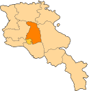
Geghadir, Kotayk
Appearance
40°09′23″N 44°39′04″E / 40.15639°N 44.65111°E
Geghadir
Գեղադիր | |
|---|---|
| Coordinates: 40°9′23″N 44°39′4″E / 40.15639°N 44.65111°E | |
| Country | Armenia |
| Province | Kotayk |
| Population (2001) | |
| • Total | 676 |
| Time zone | UTC+4 |
Geghadir (Armenian: Գեղադիր), known as Kyarpichlu until 1935,[1] is a village in the Kotayk Province of Armenia located on the Yerevan–Garni road. The ancestors of the inhabitants came from Van, Khnus, Kars, and Bitlis in 1918–1924.[2] Before that, the village was primarily populated by Turkic-speaking Muslims (i.e. Azerbaijanis).[3]
References
[edit]- ^ Kiesling, Brady (June 2000). Rediscovering Armenia: An Archaeological/Touristic Gazetteer and Map Set for the Historical Monuments of Armenia (PDF). Archived (PDF) from the original on 6 November 2021.
- ^ Կոտայքի մարզպետարան
- ^ "Գեղադիր գյուղի բնակչությունը 1831-1931 թվականներին. Կոտայքի շրջան". ANI Armenian Research Center. 14 July 2021. Retrieved 24 July 2021.


